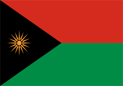
Etain

LOCATION
CLIMATES- NORTH-SKOGISH
- EAST-SKOGISH
- UPPER-SKOGISH
- SOUTH-SKOGISH
- WEST-SKOGISH
- CENTRAL-SKOGISH
- HIGHLANDER
- JUNGLE
- SWAMP
- WALDER
Legend
“Said to be the origin of the Hilt Hunters, if not, at least it delivered the most.”

History
First AgeWhen it was formed, Fril stretched along the entire Northern. Border, but alas that stretch of land sank in the 1st Cataclysm, and at the southern borders, it was as if the sunken lands ruled back up, forming a vast chain of mountains. Thus ending millennia of evolution, prosperity, and life for many tribes across multiple races.
Skjald Ulrich
Second Age
The Vampires as such made only a slight impact on society, mostly due to the already secluded ways communities had back then. So generally, they grew strong alongside the N-Erectus. Meanwhile, Humans kept struggling. Eventually, though, even the troublesome ways of humans changed into peace and prosperity. Up until the Wanderers flooded the shores.
Skjald El Mary
Third Age
Ships in far larger numbers than before, from down south of The Rim, began to dock in the harbors. Not only filled with trade goods, but with bands of people searching for something and settlers claiming lands. Conflicts rose out of this, and debates turned from skirmishes to outright war and slaughter. But for every shipload destroyed, two or three new ones arrived in the following two centuries; thus, the wanderers managed to create and keep hundreds of strongholds, as good as every Settlement.
Then came the Vular War, and although it was centred at Ljostari, its end had devastating effects, even here in Etain. As the world disrupts, the waters of the Deep Blue Tsunami and the following Arisen hit shores and lowlands somewhat hard.
Skjald Yell'a'Beard
Fourth Age
As the tainted waters retracted, bony fingers and rotting hands clawed their way back to the surface of our world. The arisen fought to find their place amongst the rest of the Races, but it was as if the worst was to come—the Liches. As nobility and settlement leaders learned how to handle these, peace began to grow, and Gods walked amongst us far more than today.
Maybe it was the gods who gifted some leaders so their families grew into Hordes; maybe it was their own doing. But the Age of Hordes became too violent for most and crippled trade and progress. Thus, some created the 1st Alliance and plotted for a unified Realm.
A realm that became a success but was toppled within a lifetime. Some kids cheering at the coronation of the first High King were the same men that flocked the same old reinstated high king. When The Great Invasion threatened their very existence,.
Together, they marched, fought, and bled. But eventually they won, and once more they parted ways. Leaving the The Scorched Dawn to children of their own.
Skjald Vinotis
Cartography

The Northern part along the whole coastline is vast grasslands with some rough hills dispersed all over. Farthest to the west, the mountain foothills extend southwards, making the vestern shores a small area called Jakolaia. Northeast of this Nafa Mounds, separates it from Tryki Valley stretching eastward and Migola to the northeast. Between Tryki Valley and Migola, Fedar Vale cuts the Nafa Mounds. Migha Mounds continues the rough lands eastwards along Tryki Valley and south of Kesqi Shore. They fade into Pitel Lowlands, before the Rexys Heights shielding off Påle Calley and Lake Påle. East of it lie Jular Marshes, Bjavnhøj, and Grintop. Then Oslok Vig cuts deep all the way to the mountains. So that it is Ghaldia that makes the borderland to Trov, either through Sugmy Sink or along the coastal road from Doggnatal.
Crossing the Border to its southeastern neighbour is done across Yakuli Bridge, spanning River Eraq streaming from Craff Lakes, sailing from the towns Bokka or Botim, or the path along the northern shores coming from Mufbi Roughs. Further north on the border lie Mt. Helzy, Mt. Kalup, Kalup's Cut, Mt. Ostyp, Mt. Njarl, Kleca Cut, Mt. Qela, Mt. Bolax, Riwfader's Run, Harna's Tips, Tolka Top, Nirvas Path, and Jugaldu Spike.
In the centre of these grasslands lies Lake Bevpi, and in the eastern part lies Lake Narrgu. South of these lies mountains, rough and cracked hills, sinkings, valleys, and kettles such as Mt. Hazy, Mt. Avbet, Mt. Linta, Mt. Pukwa and Jiqtis Spire. Kizme Kettle, Cogny Valley, Pydaq Kettle, Kais Well and Hewix Plateau. Southcentral has Lake Luvl and Lake Hikka. Further south lies Ghag Swamp and Bullik Marshes below Mufbi Roughs to the east.
Skjald El Mary
Organisation
Its currently governed by a handful of warring lesser Nobility and another score of brutal warlords.
Skjald Sigurd
Special
Up the mountains live several tribes of Indigenous and other races.
Skjald Sejrik
Last Updated on 2024-05-11 by IoM-Christian
