
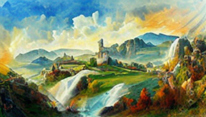
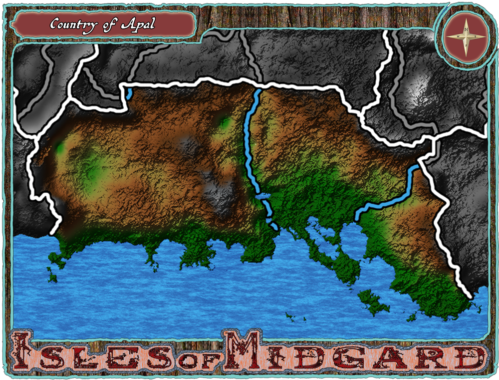
Apal

LOCATION
CLIMATES LANGUAGES- NORTH-SKOGISH
- EAST-SKOGISH
- UPPER-SKOGISH
- SOUTH-SKOGISH
- WEST-SKOGISH
- CENTRAL-SKOGISH
Egral Rulers
Noble Families & Organisations
Other Nobility
Guilds
Public Organisations
Shadowy Organisations
Thieving Organisations
Human Characters
Drakk Alfar Characters
Coinage of note:
Population: ()
Capital:
: citizens
2nd City:
: citizens
Cities:
: citizens
Towns:
: citizens
Villages:
: citizens
Hamlets:
: citizens
Rural dwellers:
Inns of note:
Taverns of note:
Rest Spots of note:
Bridges of note:
Ruins of note:
Shrines of note:
Raw Materails of note:
Legend
“Stone and rock… everything crumbles.. what a chock…”
History
In the ancient times of the first age, just after the creation of the World, Apal was a land inhabited by the Archaic, who were the first sentient beings to emerge, Drakk Alfar at several Settlements across the land, Kobold carving out strongholds in Mt. Julpag, and the Dwarves settling in Mt. Jilte. The Archaic established primitive societies along the River Fulmot, around the Stomirr Steppes, and in Olvars Kettle. These early settlements were focused on survival and cooperation, and they worshiped the natural elements and forces around them.
As time passed, the Archaic settlements began to trade with the mystical Moss'Ari, a race deeply connected to nature and magic, and previously living hidden in the deep forests. The Moss’ari shared their wisdom with the archaic, teaching them the secrets of the forest and fostering a harmonious relationship between the two races. Together with the Kobold, they established the foundation of the great Apalian Kingdom in 739 FA, forming a peaceful alliance amongst the three races that endured throughout the ages.
Meanwhile, in the western neighbor Oglan, the Ogryl, a sturdy race, who had carved out their own realm in the mountainous regions, began to migrate into Apal. The Oglan Kingdom, a formidable force, often traded resources and knowledge with the Apalian Kingdom. So, the migration was generally allowed. The two lands enjoyed a period of relative peace and prosperity during the First Age, with the mountain range a natural barrier and buffer between them.
Skjald Valgrif
As the first age drew to a close, a mysterious event unfolded, that would shape the transition into the Second Age. A dozen and a half, of Ljost- and Drakk Alfar, two powerful and enigmatic races, underwent a profound transformation into Vampires, the first generation of their kind. This unprecedented change marked the beginning of that would become known as the 1st Cataclysm.
The transformation of the Ljost Alfar and Drakk Alfar into Vampires was not a gradual process but a sudden and catastrophic event. These newly created Vampires possessed immense power and an insatiable thirst for human blood. They quickly became secretive, plotting to survive in the realms of Apal and beyond. Their emergence triggered a continent-wide conflict, known as the 1st Cataclysm. In which vampires, led by the first generation, fought for their survival. The conflict unleashed chaos and devastation, as manipulated armies fought, Gods sowed discord among races and nations, and plunged the world into chaos.
In the face of the threat, the races of Apal joined into unprecedented alliances. The Archaic, Moss’ari, Kobolds, Dwarves, and Ogryl, once divided by their differences, joined forces to resist the Vampires. As they joined the fray, so did N-Erectus, and soon the entire world was at war.
The magic used by the Vampires and their enemies unleashed catastrophic consequences on the land. The very fabric of reality was torn, resulting in unpredictable and dangerous magical anomalies. Mountains trembled, rivers changed course, and entire regions were transformed into nightmarish landscapes.
Witnessing the devastation wrought by the Vampires, ancient beings who had observed Apal’s history from the Astral decided to intervene. These mystical entities, known as the Vornir, bestowed ancient artifacts and knowledge upon the races of Apal, enabling them to combat the Vampires more effectively. But it backfired and all had to join the effort to save our world.
Thus, the Vampires walked as victors into the beginning of the Second Age. The world was scarred, but the survivors determined to rebuild and forge a new era of cooperation. The scars of the war lingered in the form of cursed lands, haunted by remnants of Magic. The 1st cataclysm became a cautionary tale, passed down through generations, reminding the inhabitants of Apal of the consequences of unchecked power and the importance of unity in the face of existential threats.
Skjald El Mary
Second Age
The great mountain… once residing at Mueta Opening… crumbled and caved…
Skjald Kazumix
In the Second Age, Apal witnessed the emerge of several races from secluded corners within its borders. T'Aurs, allies of vampires, now walked proudly. Kobolds and Dwarves also began walking the paths and roads, attracted by the trade in the thriving Apalian Kingdom. This emerge of new races brought both challenges and opportunities as the inhabitants of Apal worked to integrate the various cultures into their kingdom.
The offspring of Moss’Ari and Archaic, called Common, amongst the races. Settled throughout the Stomirr Steppes, forming nomadic communities that traversed the vast plains. The Dwarves kept expanding their strongholds in Mt. Jilte, utilizing their craftsmanship skills to connect their intricate underground cities.
The relationships with neighboring lands also evolved. Oglan and Apal forged stronger trade alliances, exchanging Resources from their respective regions through well-protected mountain passes. Esly to the north and Claun to the east began establishing contact with Apal, leading to the sharing of knowledge, trade routes, and diplomatic ties.
Skjald Sejrik
Oglan and Apal, recognizing the benefits of their longstanding alliance, formalized their relationship through a pact known as the Mountain Accord. This agreement solidified their commitment to mutual defense and trade, ensuring the continued prosperity of both nations.
Meanwhile, the relationship with Claun deepened through cultural exchanges and shared knowledge. The Valley Femtok became a meeting point for scholars, diplomats, and traders, fostering a sense of unity and understanding among the nations.
To the north, Apal and Esly collaborated on the construction of roads and paths across the Mueta Opening, a new strategic passage through the mountainous border that facilitated easier travel and trade between the two realms. This opening through the Red Mountains became a symbol of the enduring friendship between Apal and Esly.
Skjald Vinotis
As the Second Age neared its end, a profound event unfolded in the lands of Apal, reshaping the course of history. Migrating human races, known as the Vular, Jomzaar, and Rimzir, arrived in the region, some following The Bullheaded God on their divine quests. Their arrival marked the beginning of a new era and brought both blessings and challenges to the lands.
Skjald Sigurd
Third Age
As the Third Age dawned, the races of Apal experienced a period of expansion and exploration. The Wanderers, seafaring races, emerged from across The Rim in the South Sea, establishing coastal settlements and expanding their influence across the Shores.
Some of the wanderers were devoted followers of a Bull-Headed God, bringing with them a fervent faith and a rich cultural tapestry. They migrated across the vast landscapes, guided by visions and prophecies that spoke of a divine purpose awaiting them in Apal.
As the migrating races settled in various regions of Apal, their unique cultures and beliefs began to intertwine with those of the existing inhabitants. The Bull-Headed God, known as Tauragos, became a prominent deity in the pantheon of Apalian religions, and temples dedicated to Tauragos were constructed across the land.
The integration of the migrating races wasn’t without challenges. Some existing communities embraced the newcomers and the teachings of Tauragos, fostering a sense of unity and shared purpose. However, in certain regions, cultural clashes and competition for resources led to tensions between the established and migrating populations.
The Vular, Jomzaar, and Rimzir believed in divine quests centered around Tauragos. Prophecies spoke of a sacred artifact hidden deep within the heart of Apal, capable of unlocking untold power, immortality, and shaping the destiny of the world. These quests, for or afainst Tauragos, ignited a hostility among the migrating races, influencing their interactions with the land and its inhabitants.
Throughout Apal, sacred sites associated with Tauragos became focal points for pilgrimages. The Vular, and Indigenous embarked on journeys to these sites, leaving behind offerings and seeking divine guidance. These pilgrimages created a network of spiritual connections across the land, fostering a sense of unity among the indigenous and wanderers.
As the migrating races settled and integrated, the transition from the Second Age to the Third Age became a time of spiritual awakening and cultural exchange. The teachings of Tauragos influenced the art, philosophy, and governance of the region, contributing to a sense of shared identity among the races of Apal. The artifacts and knowledge brought by the migrating races became integral to Apal’s cultural heritage, influencing the development of magical practices and forging new alliances between communities.
As the Third Age unfolded, the influence of Tauragos and the migrating races continued to resonate, leaving a profound impact on the destiny of Apal and its inhabitants. Much to the dismay of the old gods, and maybe it was their whispers who misled the Vular. The conflict between the Vular and the Ljost Alfar and Dwarves on the Isle of Ljostari marked a dark chapter in Apal’s history, forever altering the fate of the land and its inhabitants. Driven by their fervent faith and a perceiv
d divine mandate, the Vular pressed on, eventually resorting to open aggression against the Ljost Alfar and Dwarves. The reasons for the conflict ranged from ideological differences, knowledge search, to territorial disputes, fueled by the belief that a divine artifact linked to Tauragos was hidden in the mountain.
The clash between the Vular and the defenders of Ljostari erupted into a full-scale conflict, known as the Vular War. The intense magical battles that unfolded on the island triggered a cataclysmic event, causing the very land beneath Ljostari to quake and sink. The once-proud island disappeared beneath the waves, leaving behind only the haunting presence of Mount Vula, an astral lingering volcano that bore witness to the island’s tragic demise.
Skjald Ulrich
Fourth Age
The sinking of Ljostari sent shockwaves across the seas, disrupting the delicate balance of magic in the region. A magically tainted tsunami surged outward, carrying with it the lingering energies of the intense conflicts on the island. As the tsunami washed shores of the world, it affected the surrounding lands, raising the dead in its wake.
The Arisen, as the reanimated corpses came to be known, were a consequence of the magically tainted tsunami. These undead beings retained some semblance of their former selves but were driven by an insatiable hunger for the life force of the living. The Arisen became a haunting presence, roaming the shores and hinterlands, instilling fear and despair in the hearts of the living.
The Vular War and the rise of the Arisen had a profound impact on the cultural fabric of Apal. The memory of Ljostari and the tragedy that unfolded became a cautionary tale, a somber reminder of the consequences of unchecked aggression and the devastating potential of magical conflicts.
Mt. Vula, the astral lingering volcano, became a mystical and foreboding landmark. It served as a constant reminder of the once-thriving island that now lay behind the fog. The magical energies emanating from Mount Vula made it a mysterious and dangerous place, influencing the flora and fauna in peculiar ways.
Skjald Sejrik
In the aftermath of the War, the surviving races of Apal, including the Vular, Ljost Alfar, and Dwarves, faced the challenge of rebuilding and healing. The Arisen continued to pose a threat, requiring joint efforts to contain and manage the undead menace. Over time, the shared memory of the tragedy served as a catalyst for unity and cooperation among the diverse races, as they sought to prevent such catastrophic conflicts from arising again in the future.
As Apal entered the fourth age, the scars of the Sundering War and the presence of the Arisen became integral parts of the region’s history, shaping the collective consciousness of its inhabitants and influencing the course of events in the centuries that followed.
The Fourth Age brought both triumphs and challenges to Apal. The Drakk Alfar, formidable crafters, strengthened their presence known in the Darkvale region, becoming a threat to the established order. Apalian forces, alongside their allies from Oglan, Esly, and Claun, faced the Drakk Alfar in a series of conflicts known as the Drakkar Wars.
These wars forged a stronger bond among the humans as they united against a common enemy. The battles tested the resilience of the Apalian Kingdom and its allies, leading to the development of advanced magical and martial techniques to combat the Drakk Alfar. Eventually the Drakk Alfar retracted into their secluded areas once more.
In the aftermath of the Drakkar Wars, Apal emerged as a resilient and united land. The nations of Oglan, Esly, and Claun continued to stand by Apal’s side, fostering an era of peace and cooperation. The various races, once separated by differences, found common ground in their shared history of triumph over adversity, laying the groundwork for a future where Apal stood as a beacon of unity and prosperity in a world filled with challenges.
Skjald El Mary
Some say the Drakkar War was about the tainted waters, either the Drakk Alfar tainting, or them trying to purify the fainted. Regardless, in the Fourth Age of Apal, the discovery of the dark potential within the magically tainted waters of the tsunami sparked a series of events that would shape the world’s destiny. As humans across the realm uncovered the secrets of these waters, a new, malevolent force emerged: the Liches.
Around year 20 FA word spread among magical practitioners and dark sorcerers that the waters touched by the magically tainted tsunami held the key to unlocking powerful necromantic rituals. Those who delved into the forbidden arts began using these waters in dark ceremonies, transforming themselves into Liches. The arcane energies infused within the tainted waters granted them unparalleled magical abilities and the gift of immortality.
The Liches, immortal and wielding formidable magical powers, became arch enemies of the Vampires. The animosity between these two factions escalated into a milennia-long conflict known as the Dance of Shadows and Blood. The Liches, driven by a thirst for power and mastery over death, sought to dominate Apal, while the Vampires, with their own ambitions, resisted the encroaching darkness.
The battles between Liches and Vampires played out across the shadowed landscapes of Apal. Ancient ruins, once vibrant cities, and desolate wastelands became the stage for the Dance of Shadows, as these immortal beings clashed in a struggle for dominance. The magically tainted waters of the tsunami remained a coveted resource, with both sides seeking to harness its dark energies to augment their own powers.
In this age of conflict, alliances formed and crumbled among mortal races. Some sought to align with either the Liches or the Vampires, believing that choosing a side would secure their survival. Others, however, resisted the influence of these dark forces, attempting to maintain a delicate balance and prevent the all-encompassing darkness from consuming the world. And an few, became hunters of one or the other, or of both.
The Fourth Age was marked by the pervasive influence of the Dance of Shadows and Blood. Regions once teeming with life were transformed into desolate battlegrounds. The once-beautiful landscapes of Apal became scarred by the ongoing conflict, with the very essence of the land tainted by the struggles between Liches and Vampires.
As the Dance of Shadows and Blood unfolded, it became clear that neither the Liches nor the Vampires could claim an absolute victory. The conflict reached a stalemate, leading to a delicate balance between the forces of undeath. The realm remained in a perpetual state of tension, with the fate of Apal hanging in the balance as these immortal beings continued their age-old struggle for dominance.
In this aftermatch the Age of Hordes grew forth, bringing order and stability back to hard tested lands, seeing trade thrive once more. From this age another, even more prosperous one rose, The Realm. Joining every known isle in a strong alliance, which stood its test in 1277 when The Great Invasion swept the lands. Emerging victorious in 1281, after the Cleansing Crusade.
As the Fourth Age persisted, Apal faced an uncertain future, caught between the shadows of the Liches and the bloodlust of the Vampires. The remaining Invaders and traitors. Nobility fighting to fill vaccuums, and villians roaming the countrysides, influence the choices and destinies of those who called Apal their home.
Skjald Vinotis
Cartography
Skjald Vinotis
Special
At the northern border between Esly and Oglan, there’s currently a growing production of granite and marble due the needed rebuilding of The Realm. This has made the are a prosperous one, but also a melting pot of beggars, cut-purses and throat-slitter’s. So it’s recommended that any visitor fare with care.
Skjald Ulrich
Last Updated on 2025-07-05 by IoM-Christian