
Fril

LOCATION
CLIMATES- NORTH-SKOGISH
- EAST-SKOGISH
- UPPER-SKOGISH
- SOUTH-SKOGISH
- WEST-SKOGISH
- CENTRAL-SKOGISH
- HIGHLANDER
- JUNGLE
- SWAMP
- WALDER
- Ubertug
Legend
“The ‘Fangs of Fril’ never drowned, they still lurk and bite, late at nite.”
History
As the ground beneath their feet began to ease its rolling and stretching, and the coloured glows from the Astral was gone. The World became silent, shrouded in utterdark only the nightvisioned Races could see what had become of the Void Gardens. After merely staring for a while, they began to move around, tend their livestock, trade, craft, and pray. A prayer growing stronger as time passed, and suddenly it was as the Divines heard the pledge. And brought light to sail across the sky, in the form of Sun and Moon.
These two were in fact Stoicheian, to forever sail the edge between the world and The Void, in a pact between Vornir, Boriac, Gods, and Stoicheian. This union between all divines but Wickeryadi, are said to be the reason Vampires came to be. Two of these, a Male Ljost Alfar named Khütu Siljêr Jā, and a Female Drakk Alfar named Igren Ellýs Sinej, took residence in Southern Fril, at the western end of the Border to Trov.
They constructed a great Obsidian stronghold, and gathered quite a crowd of followers. But when the divine ones, and several Races rose against them, and the 1st Cataclysm unfolded. The lands and their stronghold sank and created the gargantuan fjord, now residing south of Fril. With this cataclysm, a new age began.
Skjald Yell'a'beard
Second Age
As a consequence of the cataclysm, the world tilted so the rotation no longer matched the indifferent Stoicheian flying far above, the vast grid that held the inner astrals links in check was distorted, and much land sunk or became mountains and wilderness. Vampires survived the conflict, and can be counted winners, as several N-Erectus and Human Tribes supported them. Vampires never forgot who supported, and still honour milennia old deeds.
Most races and tribes also developed strong relations in the following centuries, where they had to adopt to changed lands, and shifting climates. As north became warmer and south colder, wildlife also altered behavior, so especially Hunters had to adapt.
Skjald Ulrich
Third Age
Centuries passed, and one day The Bullheaded God came, and with it plenty of Wanderers. These new humans soon lived in plentitude everywhere, mostly creating their own new Settlements. Then the Vular fought Ljost Alfar and Dwarves at Ljostari. A conflict that grew such, that the vornir came from the astral, and sang the Hymn of Truenames. Eventually it peaked in Mt. Vula erupting, sending the Deep Blue Tsunami across the world.
Skjald Vinotis
Fourth Age
Up and up and up… ancestors clawed, crawled, and climbed… to once more, claim their biddings… Arisen arrived, dead yet alive…
Skjald Kazumix
Besides the arisen, there came a time where many a Mana Manipulator tried their luck and Arcane Magic, and Void Weaving, to become Liches. Bringing yet another conflict to life, that between vampires and liches.
Alongside this some tribe families grew so powerful they became known as Hordes, mostly cutting ties with former lords, and becoming ruling lords themselves. Creating a time of conflicts, lasting up until The Realm was founded. Yet returning again, in The Great Invasion.
Skjald Valgrif
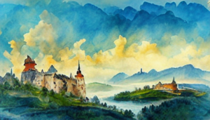
Cartography
North Fril is mainly roughlands, hills, foothils and mountains with a few large valleys and many a steepsided cleft. The Northern Border to Fridor, Sloviit and Ascal are littered with broad mountain passes and deep narrow cut clefts.
At the Frifril shore one can go through Frilfro Marsh up into Fridor. At the backside of Yumtuna Kettle Yumtu Pass leads across the mountains. So does Lefcus Valley and Culef Gate, Birza Crack at the end of Loktar Plateau. The large self governed region of Pexu Inbuk has two passes leading into Fridor; Lower Himkatu and Upper Himkatu, and four leading into Sloviit; Sjeris Cut, Lakir Ledge, Zypol Drak and Herqa Mol. At the Eastern side of Mt. Dyvmyt the Twin Mak Plateaus has one pass Mak Frida leading into Sloviit, and two passes; Vibbes Cut and Vogges Cut leading into Ascal. Further East theres also Nolga Pass, Raxi Ridge and Pezu Piyx leading up into Ascal.
The Border into Trov are through the broad Trovall and across three large bridges; Olma Gate across Olma Knoll, Vapve Gate along Vap Holm and Ve Peninsula, and Lyvre Gate from Lyvre Dam to Lutvi Holm.
To the South Fril share the gargantuan fjord with Trov and in most harbours theres also military and tax garrisons to handle the many traders and caravans landing. Southern Fril are vast grasslands and crop fields. The Southeastern part, between Begala Bay and Deertoe Ponds are a rather treacgerous marshland.
Centre are slowly raising in altitude and roughness and in the middle Mt. Gazo, Mt. Alnaf and Mt. Giztol towers.
Skjald El Mary
Organisation
Various areas are led by lesser nobility, striving for ultimate control of what was Fril.
Skjald Sejrik
Special
Ancient artefacts from the sunken lands washed ashore, or found by divers.
Skjald Vinotis
Last Updated on 2026-06-27 by IoM-Christian